CIVIL PARISH OF PRISCOS
CIVIL PARISH OF PRISCOS
Priscos has always been celebrated as a land which integrates the territory of Braga. Located in the valley of the Este river, the people of Priscos found a source of livelihood in this well-exposed and fertile place. In addition, its patron saint derives from one of the primitive pilgrimage routes to Santiago de Compostela which was located along the river margin.
Priscos has always been celebrated as a land which integrates the territory of Braga. Located in the valley of the Este river, the people of Priscos found a source of livelihood in this well-exposed and fertile place. In addition, its patron saint derives from one of the primitive pilgrimage routes to Santiago de Compostela which was located along the river margin.
Originally part of the Lands of Penafiel de Bastuço and the Comarca (a medieval territorial subdivision) of Barcelos, it was later integrated in the jurisdiction of Braga, starting from 1836. Home of the medieval manor of an illustrious nobleman, whose family was founded in the neighbouring Lands of Faria, and whose brother, the renowned D. Gualdim Pais of Marecos, who was one of the main characters of the foundation of Portugal, Priscos was destined to emerge from anonymity early on.
Centre of an ecclesial communion prior to the re-establishment of the Diocese of Braga in the 11th century, this parish would have emerged around the temple devoted to São Tiago (Saint James the Great), during a period prior to this one.
HISTORY
The first known donee of Priscos was D. Gomes Pais, brother of D. Gualdim Pais.
The first news about Priscos dates back precisely to its ecclesiastical demarcation, being mentioned as a parish devoted to São Tiago (Saint James the Great) in the late 11th century. Some allusions to a feudal manor in possession of an important family from the Entre-Douro-e-Minho province were written shortly after.
As a community prior to the Portuguese nation, Priscos would have emerged during the High Middle Ages, in the historical period that succeeded the Visigothic domain. And, contrary to what historiography has been suggesting, we know today that the human occupation of this region occurred during the Muslim rule of the Iberian Peninsula, even with some level of social organisation. The evolution of the Reconquista (Christian reconquest) campaign, continuously promoted by the Christian kingdoms, resulted in the progressive dominance of these lands by the ruling elites.
The first known donee of Priscos was D. Gomes Pais, brother of D. Gualdim Pais, fourth Grand Master of the Knights Templar in Portugal, and son of D. Paio Ramires and his second wife, D. Gontrode Soares, from the Correias noble family of Fralães, who might have left “a great lineage, particularly of Cunhas”. In the early 18th century, the Corografia Portugueza, a Portuguese chorography manuscript, highlights Priscos for being the manor and place of residence of D. Gomes Pais of Priscos. It is very likely that its residential space was located in a central position regarding the civil parish territory, and it is reasonable to assume that it used to be where the Parish Church and its Grounds are currently located. The toponym “Torre” (tower) can be found nearby, which may suggest the space-time seat of the manor of Priscos.

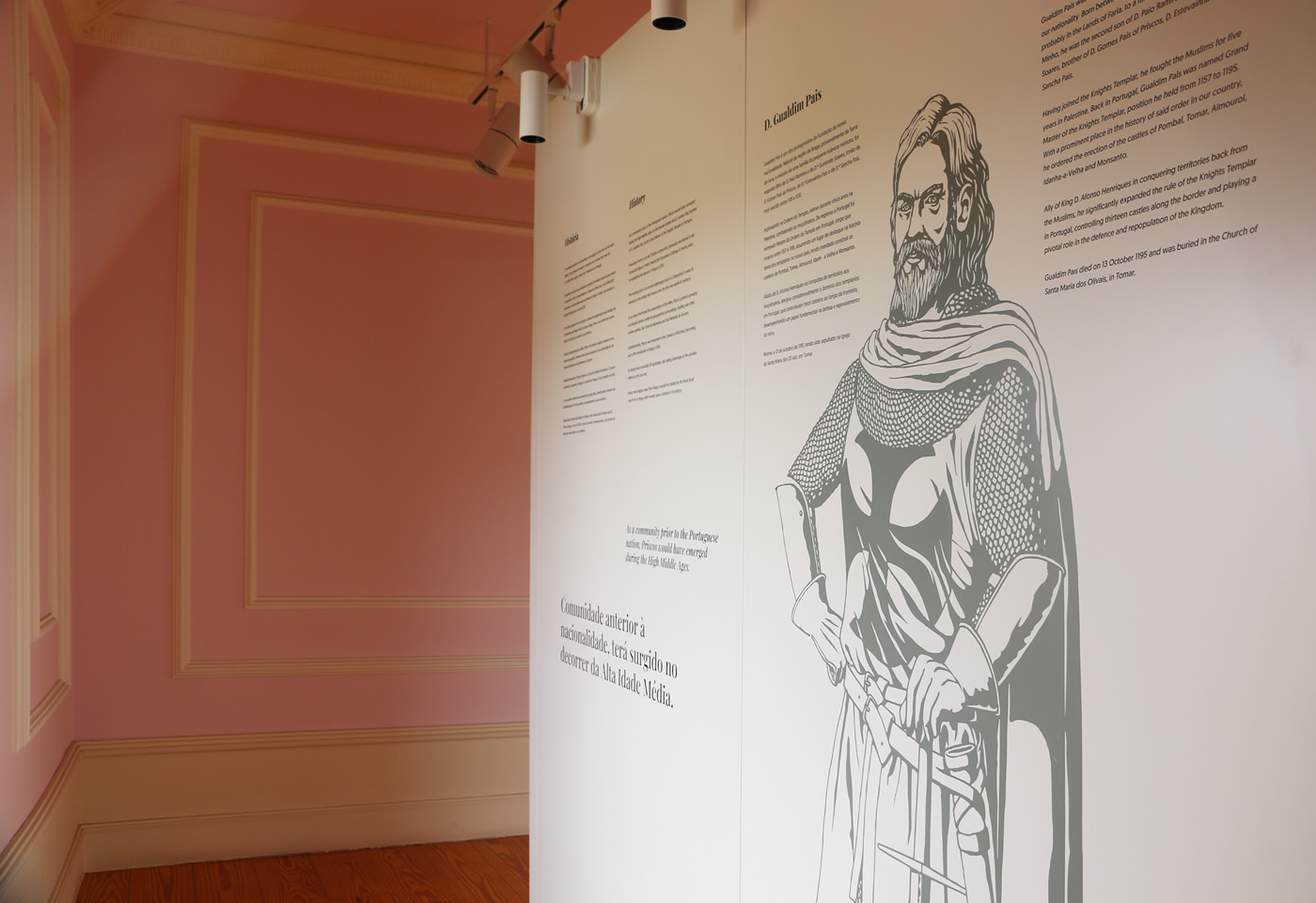
Gualdim Pais
Gualdim Pais was one of the main characters of the foundation of our nationality. Born between 1118 and 1120, in the region of Braga, probably in the Lands of Faria, to a family of lower nobility from Minho, he was the second son of D. Paio Ramires and D. Gontrode Soares, brother of D. Gomes Pais of Priscos, D. Estevaínha Pais and D. Sancha Pais. Having joined the Knights Templar, he fought the Muslims for five years in Palestine. Back in Portugal, Gualdim Pais was named Grand Master of the Knights Templar, position he held from 1157 to 1195. With a prominent place in the history of said order in our country, he ordered the erection of the castles of Pombal, Tomar, Almourol, Idanha-a-Velha and Monsanto. Ally of King D. Afonso Henriques in conquering territories back from the Muslims, he significantly expanded the rule of the Knights Templar in Portugal, controlling thirteen castles along the border and playing a pivotal role in the defence and repopulation of the Kingdom. Gualdim Pais died on 13 October 1195 and was buried in the Church of Santa Maria dos Olivais, in Tomar.
Certainly because of its lordship relevance, Priscos was also home to an old Christian community, previously mentioned, during the 11th century, in the Censual de Entre Lima e Ave (1084-1091), a census manuscript document written under the prelature of Bishop D. Pedro, who re-established the Diocese of Braga after 1070. Nonetheless, the hypothesis of the existence of a small church or chapel devoted to São Tiago (Saint James the Great), with some inhabitants living in its surroundings, prior to that date, is still not disregarded.
The crossing point of an ancient pilgrimage route to Santiago de Compostela
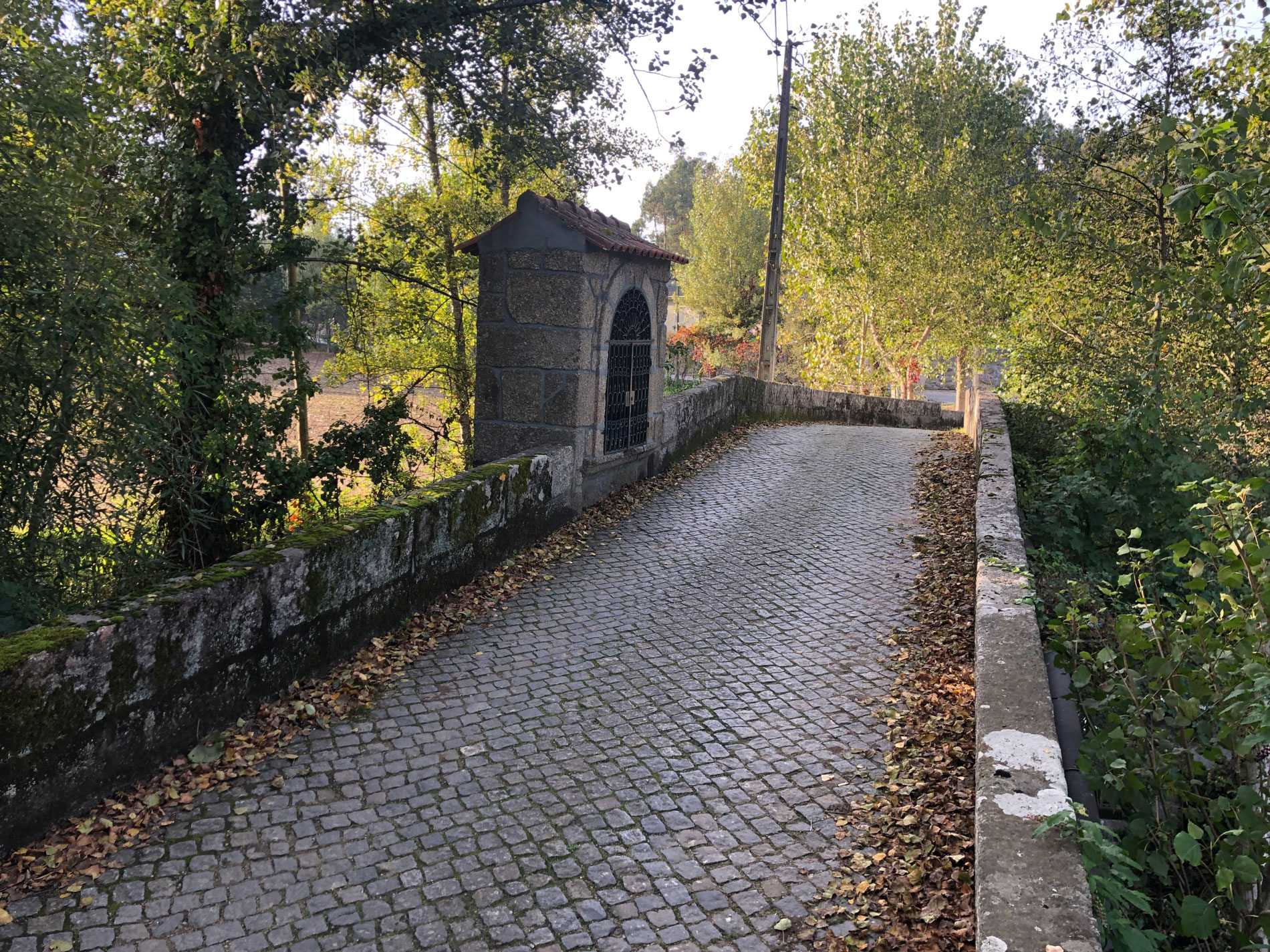
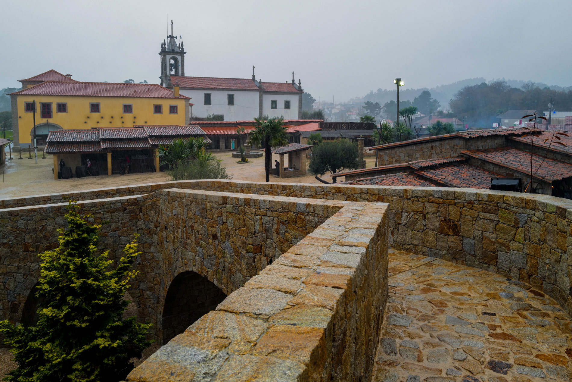
Connected Vila do Conde to Braga, passing through Rates and Arnoso right before Priscos, it owes its relevance to the bridge that crosses over the Este river within its territory. Despite not being part of the main pathway, which went from Porto along the old Roman route close to Veiga de Penso, this bridge was especially used during the construction of the Barcelos bridge over the Cávado river in the 14th century, which started to concentrate the movement coming from the coastline. This pathway and the privileged crossing over the Este river were the defining axis of the community in the early centuries of its existence.
As an abbey that hosted the presentation of the Mitre, the parish of Priscos gained a growing and singular primacy within its geographical surroundings, holding two other smaller parishes: São Tomé de Moimenta and São Mamede de Sezures. The extinction of the parish of São Tomé de Moimenta and its definitive union with the parish of Santiago of Priscos occurred on 18 November 1599. In turn, Sezures was granted autonomy and is now part of the Famalicão territory.
Administratively, Priscos integrated the Lands of Penafiel de Bastuço, a medieval Comarca which was seated in a neighbouring castle. The Castle of Penafiel de Bastuço was, during the Middle Ages and almost up to the Modern Age, the administrative centre of a vast territory. From this castle, a military fortress, which controlled the valley of the Labriosque river and was mentioned as early as the primitive territory of the County of Portugal (MATTOSO, 1995), remain to this day some scarce traces. Said situation was maintained during the 15th century.
Priscos was then integrated in the municipality of Braga following the reform of the Portuguese municipalities of 6 November 1836
Up until that moment, it was part of the Comarca of Barcelos, belonging to the district and court of Penafiel de Bastuço, also part of the Comarca of Barcelos.
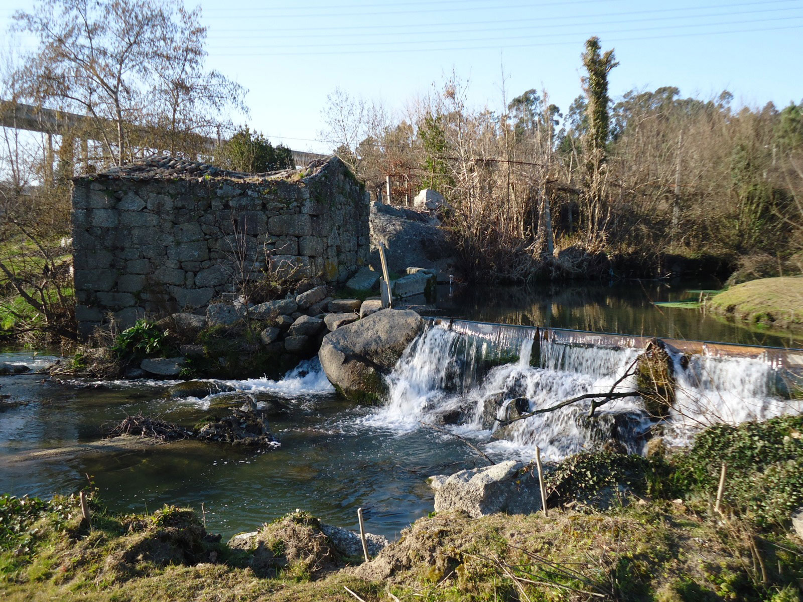
Its people, early on controlled by the power of the Lord, lived essentially off agriculture, farming the fertile land and raising cattle, taking advantage of the exceptional conditions offered by the Este river. Also, due to the river, several watermills were built along its margins and whose traces still remain.
Almost two leagues away from the city of Braga, the construction of the Royal Road from Porto to Braga in 1853, granted Priscos with a new centrality as it crossed the north-eastern area of its territory, immediately after the famous voltas de Macada (sequence of sharp curves), in the neighbouring civil parish of Vimieiro. Brought back from oblivion by this roadway, Priscos would stay in the spotlight with the contemporary version of national road EN14, which provoked a division in its territory, making the communication difficult between the two opposing sides of the civil parish.
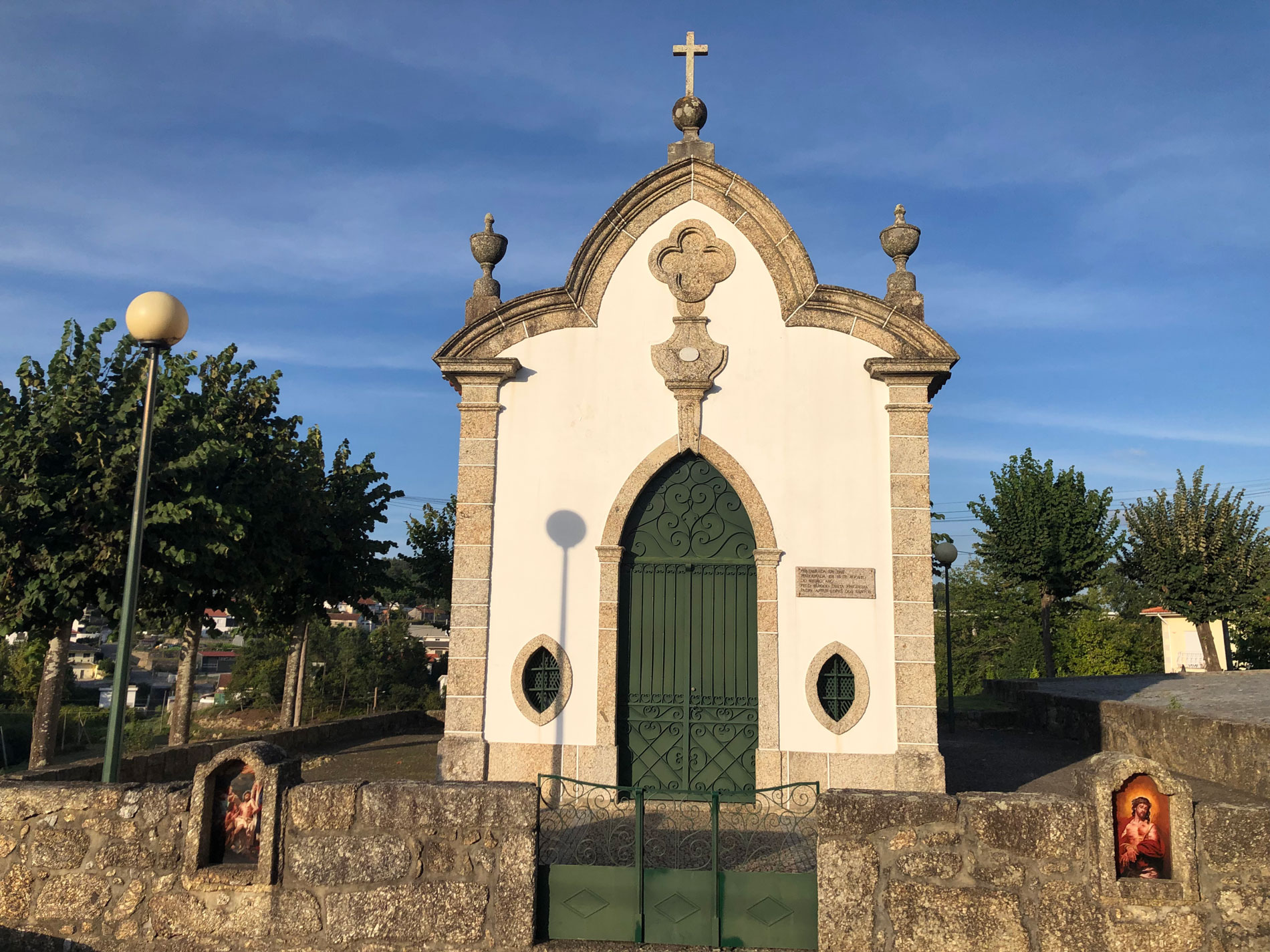
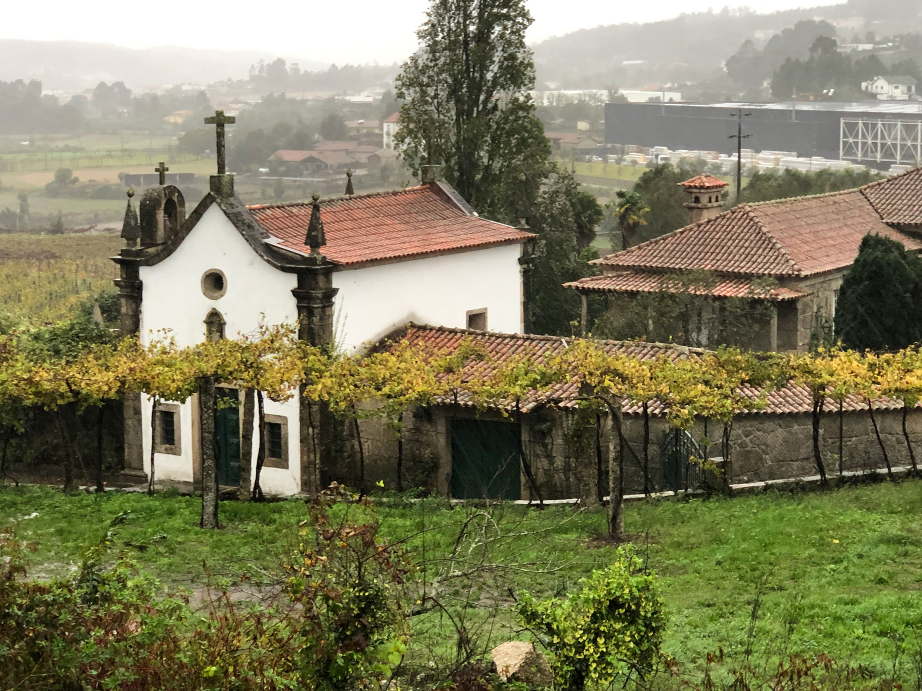
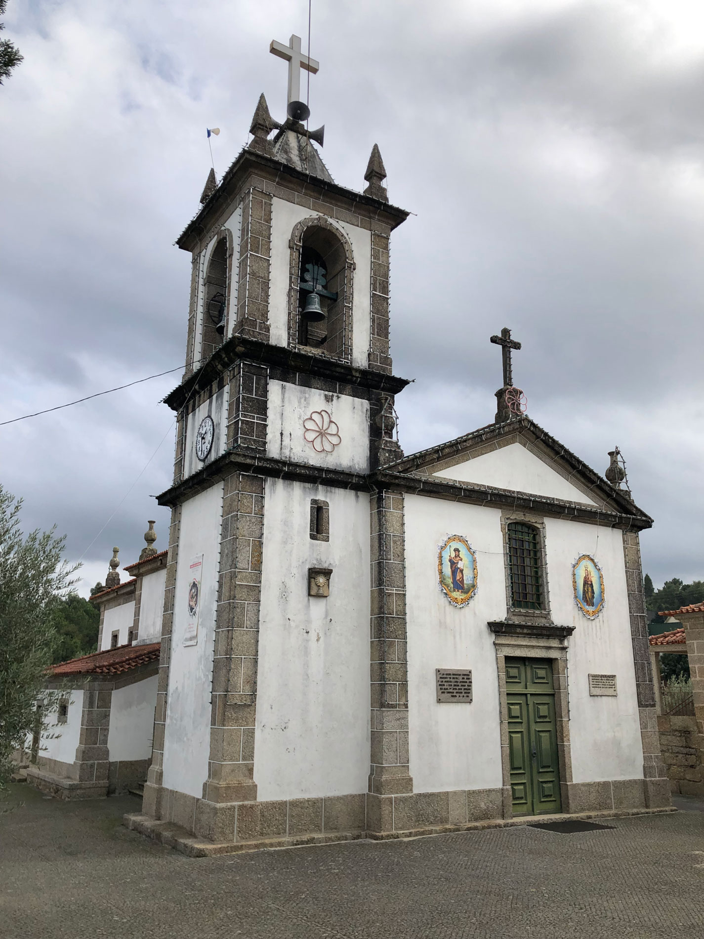
In addition to the Parish Church and its Grounds, rebuilt in the late 18th century, the monumental heritage of Priscos comprises the Chapel of Senhor dos Passos (Our Lord of the Stations), the House and Chapel of São Tomé de Moimenta, the Romanesque bridge with its wayside shrines, and the set of watermills present along the margins of the Este river.
Originally part of the Lands of Penafiel de Bastuço and the Comarca (a medieval territorial subdivision) of Barcelos, it was later integrated in the jurisdiction of Braga, starting from 1836. Home of the medieval manor of an illustrious nobleman, whose family was founded in the neighbouring Lands of Faria, and whose brother, the renowned D. Gualdim Pais of Marecos, who was one of the main characters of the foundation of Portugal, Priscos was destined to emerge from anonymity early on.
Centre of an ecclesial communion prior to the re-establishment of the Diocese of Braga in the 11th century, this parish would have emerged around the temple devoted to São Tiago (Saint James the Great), during a period prior to this one.
HISTORY
The first known donee of Priscos was D. Gomes Pais, brother of D. Gualdim Pais.
The first news about Priscos dates back precisely to its ecclesiastical demarcation, being mentioned as a parish devoted to São Tiago (Saint James the Great) in the late 11th century. Some allusions to a feudal manor in possession of an important family from the Entre-Douro-e-Minho province were written shortly after.
As a community prior to the Portuguese nation, Priscos would have emerged during the High Middle Ages, in the historical period that succeeded the Visigothic domain. And, contrary to what historiography has been suggesting, we know today that the human occupation of this region occurred during the Muslim rule of the Iberian Peninsula, even with some level of social organisation. The evolution of the Reconquista (Christian reconquest) campaign, continuously promoted by the Christian kingdoms, resulted in the progressive dominance of these lands by the ruling elites.
The first known donee of Priscos was D. Gomes Pais, brother of D. Gualdim Pais, fourth Grand Master of the Knights Templar in Portugal, and son of D. Paio Ramires and his second wife, D. Gontrode Soares, from the Correias noble family of Fralães, who might have left “a great lineage, particularly of Cunhas”. In the early 18th century, the Corografia Portugueza, a Portuguese chorography manuscript, highlights Priscos for being the manor and place of residence of D. Gomes Pais of Priscos. It is very likely that its residential space was located in a central position regarding the civil parish territory, and it is reasonable to assume that it used to be where the Parish Church and its Grounds are currently located. The toponym “Torre” (tower) can be found nearby, which may suggest the space-time seat of the manor of Priscos.
Gualdim Pais
Gualdim Pais was one of the main characters of the foundation of our nationality. Born between 1118 and 1120, in the region of Braga, probably in the Lands of Faria, to a family of lower nobility from Minho, he was the second son of D. Paio Ramires and D. Gontrode Soares, brother of D. Gomes Pais of Priscos, D. Estevaínha Pais and D. Sancha Pais. Having joined the Knights Templar, he fought the Muslims for five years in Palestine. Back in Portugal, Gualdim Pais was named Grand Master of the Knights Templar, position he held from 1157 to 1195. With a prominent place in the history of said order in our country, he ordered the erection of the castles of Pombal, Tomar, Almourol, Idanha-a-Velha and Monsanto. Ally of King D. Afonso Henriques in conquering territories back from the Muslims, he significantly expanded the rule of the Knights Templar in Portugal, controlling thirteen castles along the border and playing a pivotal role in the defence and repopulation of the Kingdom. Gualdim Pais died on 13 October 1195 and was buried in the Church of Santa Maria dos Olivais, in Tomar.
Certainly because of its lordship relevance, Priscos was also home to an old Christian community, previously mentioned, during the 11th century, in the Censual de Entre Lima e Ave (1084-1091), a census manuscript document written under the prelature of Bishop D. Pedro, who re-established the Diocese of Braga after 1070. Nonetheless, the hypothesis of the existence of a small church or chapel devoted to São Tiago (Saint James the Great), with some inhabitants living in its surroundings, prior to that date, is still not disregarded.
The crossing point of an ancient pilgrimage route to Santiago de Compostela
Connected Vila do Conde to Braga, passing through Rates and Arnoso right before Priscos, it owes its relevance to the bridge that crosses over the Este river within its territory. Despite not being part of the main pathway, which went from Porto along the old Roman route close to Veiga de Penso, this bridge was especially used during the construction of the Barcelos bridge over the Cávado river in the 14th century, which started to concentrate the movement coming from the coastline. This pathway and the privileged crossing over the Este river were the defining axis of the community in the early centuries of its existence.
As an abbey that hosted the presentation of the Mitre, the parish of Priscos gained a growing and singular primacy within its geographical surroundings, holding two other smaller parishes: São Tomé de Moimenta and São Mamede de Sezures. The extinction of the parish of São Tomé de Moimenta and its definitive union with the parish of Santiago of Priscos occurred on 18 November 1599. In turn, Sezures was granted autonomy and is now part of the Famalicão territory.
Administratively, Priscos integrated the Lands of Penafiel de Bastuço, a medieval Comarca which was seated in a neighbouring castle. The Castle of Penafiel de Bastuço was, during the Middle Ages and almost up to the Modern Age, the administrative centre of a vast territory. From this castle, a military fortress, which controlled the valley of the Labriosque river and was mentioned as early as the primitive territory of the County of Portugal (MATTOSO, 1995), remain to this day some scarce traces. Said situation was maintained during the 15th century.
Priscos was then integrated in the municipality of Braga following the reform of the Portuguese municipalities of 6 November 1836
Up until that moment, it was part of the Comarca of Barcelos, belonging to the district and court of Penafiel de Bastuço, also part of the Comarca of Barcelos.
Its people, early on controlled by the power of the Lord, lived essentially off agriculture, farming the fertile land and raising cattle, taking advantage of the exceptional conditions offered by the Este river. Also, due to the river, several watermills were built along its margins and whose traces still remain.
Almost two leagues away from the city of Braga, the construction of the Royal Road from Porto to Braga in 1853, granted Priscos with a new centrality as it crossed the north-eastern area of its territory, immediately after the famous voltas de Macada (sequence of sharp curves), in the neighbouring civil parish of Vimieiro. Brought back from oblivion by this roadway, Priscos would stay in the spotlight with the contemporary version of national road EN14, which provoked a division in its territory, making the communication difficult between the two opposing sides of the civil parish.
In addition to the Parish Church and its Grounds, rebuilt in the late 18th century, the monumental heritage of Priscos comprises the Chapel of Senhor dos Passos (Our Lord of the Stations), the House and Chapel of São Tomé de Moimenta, the Romanesque bridge with its wayside shrines, and the set of watermills present along the margins of the Este river.
TOPONOMY
Through the analysis of the oldest documentation mentioning the name Priscos, we have become aware of its toponymic evolution, which presents a slight variation during the Middle Ages, most frequently prevailing the term “Piiscos”.
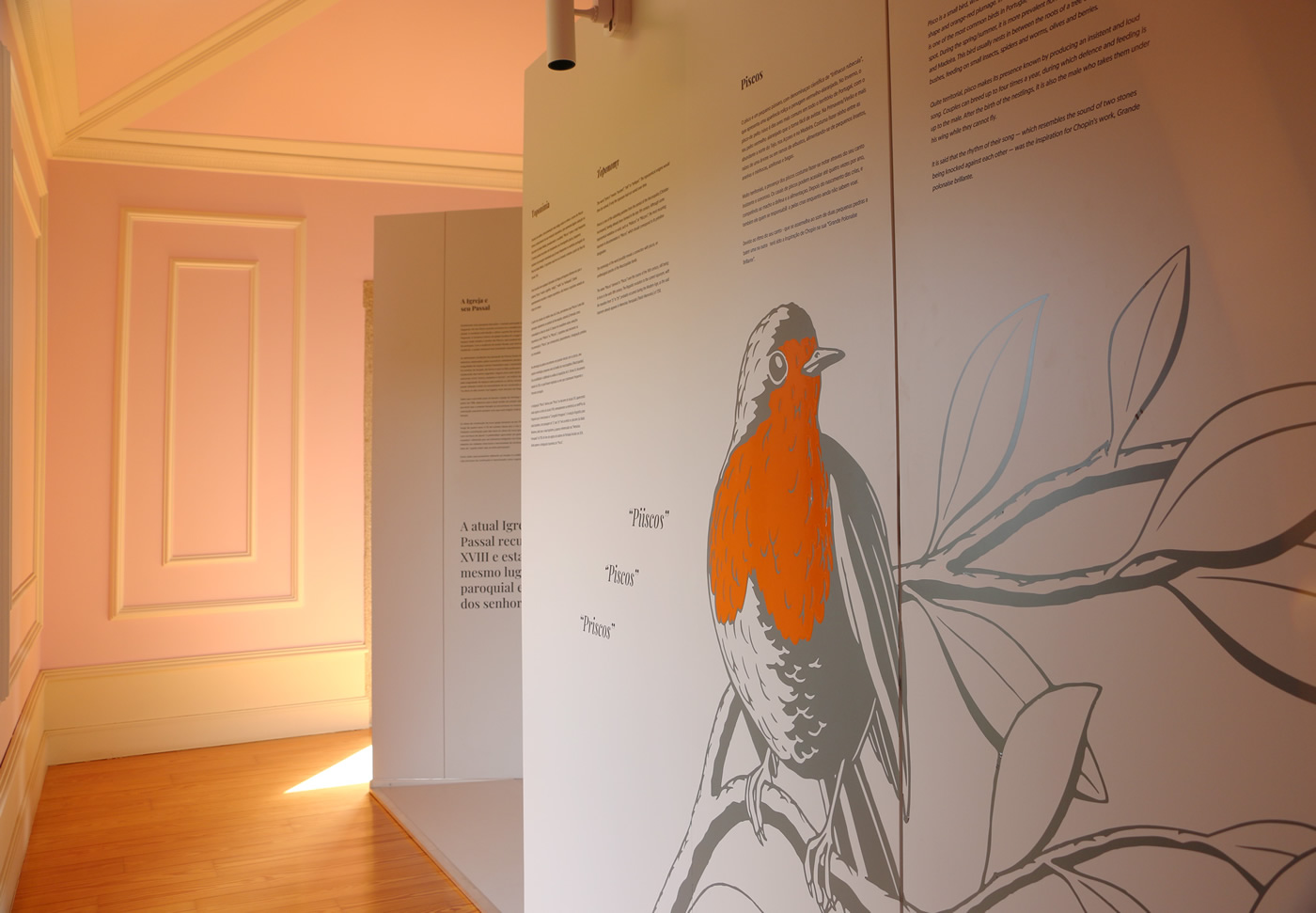
The word might have its foundation in the homograph piscos, small birds with reddish plumage, which were already frequent in the Portuguese territory in the Late Middle Ages. The current toponym most likely entered into force starting from the late 17th century.
Toponymy is a fundamental aspect for the study of the origin of a certain place. The name by which said place became known generally corresponds to a given element of its identity, which both time and the community ended up assimilating. In the specific case of Priscos, we managed to infer its toponymic evolution through the diverse mentions in the oldest documentation available, although its semantics was not entirely clear.
An incursion into any Portuguese dictionary will tell us the word “prisco” exists and means “ancient”, “old” or “antique”. The toponymical enigma would then be solved, if only the toponym had not varied over time.
Based on the studies performed by Avelino Jesus da Costa in his work O Bispo D. Pedro e a organização da Arquidiocese de Braga (Bishop D. Pedro and the organisation of the Archdiocese of Braga), we may conclude that Priscos is one of the subsisting parishes from the period of the Reconquista, having already been formed as a community in the late 11th century. Although some toponymical variations co-exist, such as “Pidiscos” or “Piiscyos”, the most recurring toponym in documentation is “Piiscos”, which plausibly should correspond to the primitive designation of this community.
The etymology of the word possibly reveals a connection with piscos, an ornithological species of the Muscicapidae family. This possibility was highlighted through the analysis of Inquirições de D. Afonso III, a document dated from 1258, in which the bird species that frequently were seen in the north-west of Portugal were registered, whose presence can be verified by a toponymical examination, and among which were also the piscos.

Piscos
Pisco is a small bird, whose scientific name is Erithacus rubecula, presenting a rounded shape and orange-red plumage. In the winter, the pisco-de-peito-ruivo (European robin) is one of the most common birds in Portugal, with its orange-red breast making it easy to spot. During the spring/summer, it is more prevalent north of the Tagus river, the Azores and Madeira. This bird usually nests in between the roots of a tree or on the branches of bushes, feeding on small insects, spiders and worms, olives and berries. Quite territorial, pisco makes its presence known by producing an insistent and loud song. Couples can breed up to four times a year, during which defence and feeding is up to the male. After the birth of the nestlings, it is also the male who takes them under his wing while they cannot fly.
It is said that the rhythm of their song — which resembles the sound of two stones being knocked against each other — was the inspiration for Chopin’s work, Grande polonaise brillante.
The name “Piiscos” derived to “Piscos” over the course of the 16th century.
Still being in force in the early 18th century, namely in the reference to the civil parish territory made in Corografia Portugueza. The linguistic evolution to the current toponym, with the transition from “p” to “pr”, probably occurred during the Modern Age, as the said toponym already appears duly referenced in Memórias Paroquiais (Parish Memories) written in 1758.
Based on previous cartographies and compendiums, Corografia Portugueza might not have duly registered the toponym update and, for that reason, we believe that the current name might have already been in use in the late 17th century. In the baptism register of the parish of Santiago de Priscos, started in 1674, the toponymical designation “Piscos” can still be read.
TOPONOMY
Through the analysis of the oldest documentation mentioning the name Priscos, we have become aware of its toponymic evolution, which presents a slight variation during the Middle Ages, most frequently prevailing the term “Piiscos”.
The word might have its foundation in the homograph piscos, small birds with reddish plumage, which were already frequent in the Portuguese territory in the Late Middle Ages. The current toponym most likely entered into force starting from the late 17th century.
Toponymy is a fundamental aspect for the study of the origin of a certain place. The name by which said place became known generally corresponds to a given element of its identity, which both time and the community ended up assimilating. In the specific case of Priscos, we managed to infer its toponymic evolution through the diverse mentions in the oldest documentation available, although its semantics was not entirely clear.
An incursion into any Portuguese dictionary will tell us the word “prisco” exists and means “ancient”, “old” or “antique”. The toponymical enigma would then be solved, if only the toponym had not varied over time.
Based on the studies performed by Avelino Jesus da Costa in his work O Bispo D. Pedro e a organização da Arquidiocese de Braga (Bishop D. Pedro and the organisation of the Archdiocese of Braga), we may conclude that Priscos is one of the subsisting parishes from the period of the Reconquista, having already been formed as a community in the late 11th century. Although some toponymical variations co-exist, such as “Pidiscos” or “Piiscyos”, the most recurring toponym in documentation is “Piiscos”, which plausibly should correspond to the primitive designation of this community.
The etymology of the word possibly reveals a connection with piscos, an ornithological species of the Muscicapidae family. This possibility was highlighted through the analysis of Inquirições de D. Afonso III, a document dated from 1258, in which the bird species that frequently were seen in the north-west of Portugal were registered, whose presence can be verified by a toponymical examination, and among which were also the piscos.
Piscos
Pisco is a small bird, whose scientific name is Erithacus rubecula, presenting a rounded shape and orange-red plumage. In the winter, the pisco-de-peito-ruivo (European robin) is one of the most common birds in Portugal, with its orange-red breast making it easy to spot. During the spring/summer, it is more prevalent north of the Tagus river, the Azores and Madeira. This bird usually nests in between the roots of a tree or on the branches of bushes, feeding on small insects, spiders and worms, olives and berries. Quite territorial, pisco makes its presence known by producing an insistent and loud song. Couples can breed up to four times a year, during which defence and feeding is up to the male. After the birth of the nestlings, it is also the male who takes them under his wing while they cannot fly.
It is said that the rhythm of their song — which resembles the sound of two stones being knocked against each other — was the inspiration for Chopin’s work, Grande polonaise brillante.
The name “Piiscos” derived to “Piscos” over the course of the 16th century.
Still being in force in the early 18th century, namely in the reference to the civil parish territory made in Corografia Portugueza. The linguistic evolution to the current toponym, with the transition from “p” to “pr”, probably occurred during the Modern Age, as the said toponym already appears duly referenced in Memórias Paroquiais (Parish Memories) written in 1758.
Based on previous cartographies and compendiums, Corografia Portugueza might not have duly registered the toponym update and, for that reason, we believe that the current name might have already been in use in the late 17th century. In the baptism register of the parish of Santiago de Priscos, started in 1674, the toponymical designation “Piscos” can still be read.
TERRITORY AND POPULATION
TERRITORY AND POPULATION
TERRITORY AND POPULATION
